Coastal altimetry - Litto3D®
Mis à jour le 05/11/2024Litto3D®, continuous mapping of the coastal fringe ...
In 2002, the European Parliament and the Council of the European Union recommended that Member States establish national strategies for the management of coastal zones in order in particular to preserve the integrity and functioning of the coastal environment but also to take into account the climate changes that threaten it.
In this context, the interministerial committee for the sea of April 29, 2003 ordered a Coastal Geographic Reference (RGL) from Shom and the IGN, the objective of which is to provide integrated cartgrahy of the coastal zone.
The creation of this RGL is based on the acquisition, processing and dissemination of coastal data: this is the Litto3D® program, designed to meet multiple mapping needs for :
- Coastal protection (coastline evolution due to erosion, protection of coastal areas, protection of flora and fauna)
- Risk prevention (flooding, pollution, natural disasters)
- Development (ports, tourism, industry)
- Exploitation of living and mineralresources
- Scientific research and studies
- Military needs
... based on a cutting-edge acquisition technique: LiDAR
Within the Litto3D® program, the Shom is in charge of the maritime part - from the top of the foreshore to a depth of 30 meters. Data acquisition is carried out by LiDAR: airborne topographic and bathymetric lasers that scan the ground and seabed to map relief.
- A “red” laser for topographic surveys, concerning exclusively the land areas at the time of the survey.
- • Two “green” lasers for bathymetric surveys, for submerged land. These lasers have many advantages such as the ability to quickly map large areas, the possibility of probing dangerous or inaccessible areas by sea, and the ease of continuously probing the strip of coastal water and the intertidal zone.
Easily accessible data to meet user expectations
The product is available in two forms: three-dimensional point seedings (ground, above ground) and meshed and qualified digital terrain models (1m and 5m resolution), all structured in 1km² slabs.
Use of Litto3D® data is open, free and unrestricted (Open License ). They can be downloaded from diffusion.shom.fr and viewed on data.shom.fr (Reference data section > Coastal altimetry).
A few examples of concrete applications for Litto3D® data
Forecasting marine submersions

Litto3D® data makes it possible to improve the forecasting capabilities of the national Wave Submersion Vigilance system operated by Météo France.
Action Program for Flood Prevention


As part of the Saint-Malo Flood Prevention Action Program, Litto3D® data from Brittany and Normandy have been merged with acoustic sounder data to provide a high-resolution bathymetric model for the area around Saint-Malo and for the entire Normandy-Breton Gulf. This model will feed future forecasting capabilities for marine submersion and flooding risks on land.
Application for the benefit of navigation


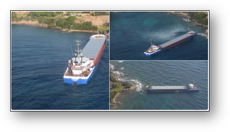
Thanks to Litto3D® data, a safe route has been defined for the Rhodanus to leave following its grounding on the coast of Corsica in October 2019.

